


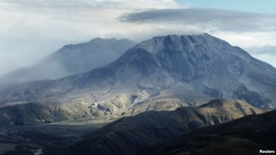
A series of explosions set off by a team of scientists were expected to rattle Washington state's Mount St. Helens on Wednesday as researchers map the interior of the volcano, whose 1980 eruption was the deadliest in U.S. history.
Mount St. Helens, about 95 miles (150 km) south of Seattle and 50 miles (80 km) north of Portland, erupted in an explosion of hot ash in May 1980, spewing debris over a wide area, killing 57 people and causing more than a billion dollars in damage.
Scientists from across the United States are trying to get a better handle on the magma stores and internal workings of the 8,300-foot (2,530-meter) volcano to improve warning systems prior to eruption.
"Mount St. Helens and other volcanoes in the Cascade Range threaten urban centers from Vancouver to Portland," lead scientist Alan Levander of Rice University in Houston said in a statement.
Residents living near Mount St. Helens were unlikely to feel the shots because of their depth, but their insertion approximates a magnitude 2 earthquake, scientists said.
In May, the U.S. Geological Survey said that magma levels were slowly rebuilding inside Mount St. Helens, but there was no sign of an impending eruption

Bütün xəbərlər Facebook səhifəmizdə
































 USD
USD
 EUR
EUR
 GBP
GBP
 RUB
RUB